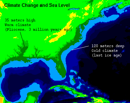
Image depicts the largest changes in global eustatic sea level that have been inferred from geological studies. The light blue color shows an estimate of the coastline of the eastern United States during the last glacial maximum, about 20,000 years ago. The dark green shows the modern coastline, and the lighter shades of green show the coastlines that may have existed during the warm climatic interval of the middle Pliocene epoch, about 3 million years ago. (Expected global coastlines with eustatic sea-level of -120, 0, 35, and 60 meters from present are shown without accounting for ice loading.)
Images based on Global Gridded Pliocene and Late Quaternary Sea Level, U.S. Geological Survey Open-File Report 96-000, by Peter N. Schweitzer and Robert S. Thompson.
Sources:
http://geochange.er.usgs.gov/pub/sea_level/
http://geochange.er.usgs.gov/pub/sea_level/Core/raw/pliocene/images/chg05t.pict